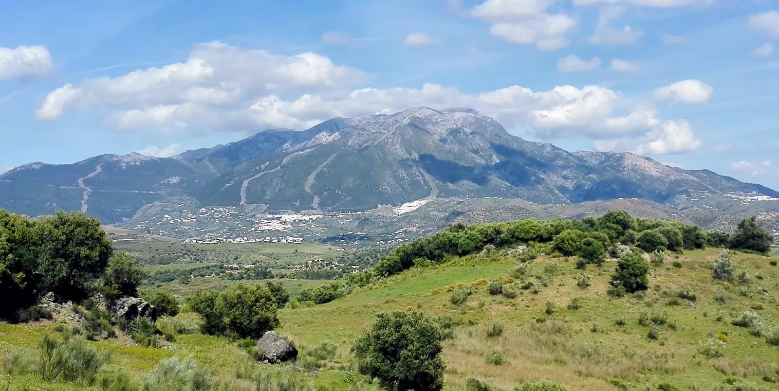
La Maroma Hike from Canillas de Aceituno
Trail description
⛰️ A high-mountain route
It is 17.7 km there and back with 1,420 m of climbing between the village and the summit, with almost no shade and no water in the second half. Fog, snow or ice change it completely: check the forecast for the summit, not just the coast.
La Maroma (2,069 m) is the highest mountain in the Axarquía and the snow-capped peak you can see from Nerja in winter. The classic ascent starts in Canillas de Aceituno on the waymarked SL-A 142 "Canillas de Aceituno – Casa de la Nieve" trail, inside the Sierras de Tejeda, Almijara y Alhama Natural Park: the old path the snow gatherers used to bring ice down from the mountain. It is the south face, the sunniest and the toughest, with sea views for most of the climb.
Trail map
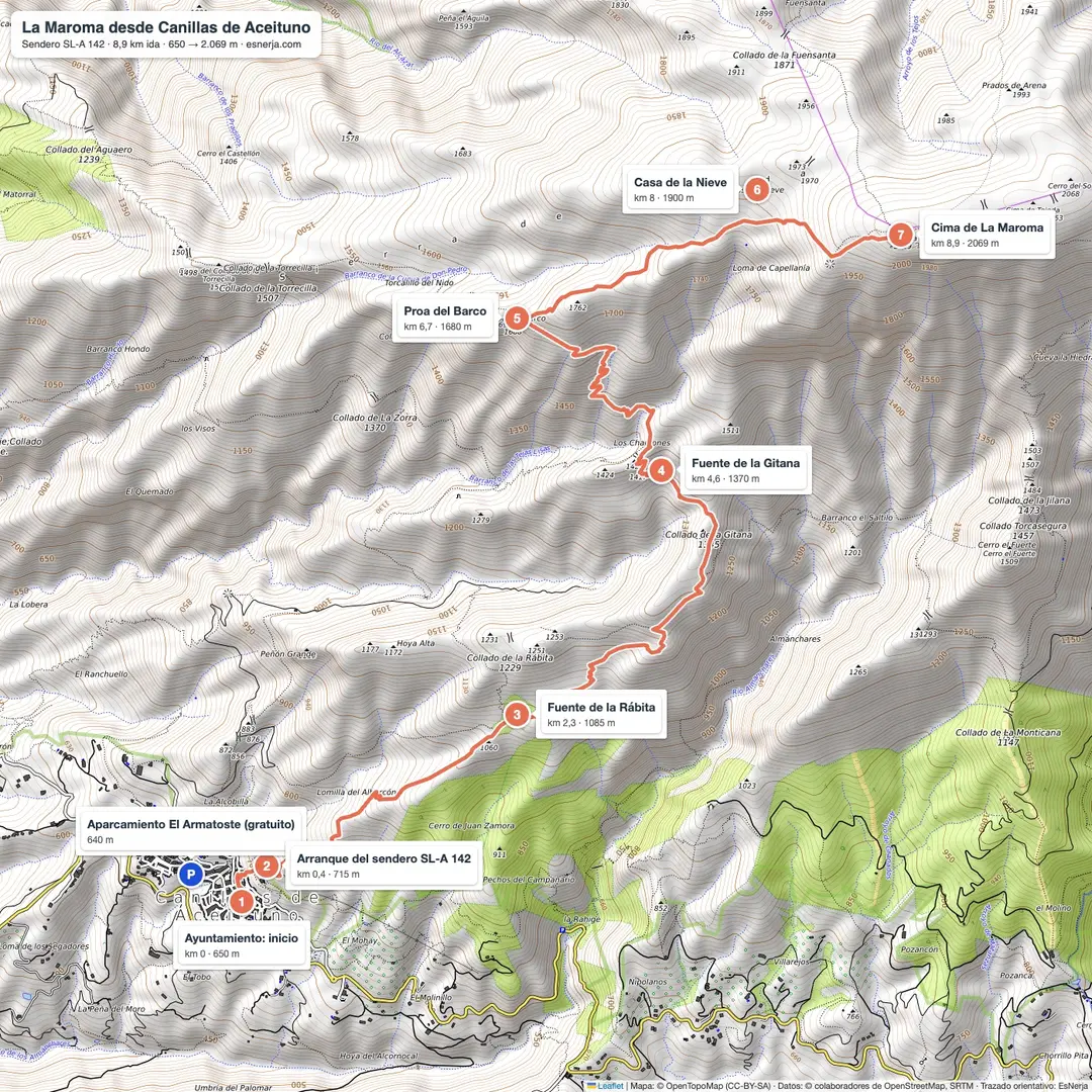
Trail facts
- Start: Canillas de Aceituno town hall (650 m), 42 km from Nerja.
- Distance: 8.9 km to the summit; 17.7 km there and back on the same path.
- Elevation: 1,420 m from the village to the summit; about 1,550 m of total ascent.
- Time: 4–5 h up and 3–3.5 h down; 7 to 9 h including stops.
- Difficulty: hard because of length and climbing; no technical sections when the path is dry.
- Waymarking: white and green SL-A 142 marks and, higher up, stone cairns.
- Water: Rábita spring (km 2.3) and Gitana spring (km 4.6, irregular flow). Nothing after that.
- Best time: spring and autumn. In summer, start at dawn; in winter, with snow, only with crampons and an ice axe.
The climb, section by section
Canillas – Rábita spring (km 0–2.3). From the town hall square, walk up Calle del Convento to the trail sign at the top of the village (where the El Saltillo path branches off). The path climbs relentlessly through almond trees and scrub: 435 m in just over 2 km. The Rábita spring, with the cave of the same name beside it, is the first stop.
Rábita – Los Charcones (km 2.3–5). The path eases a little along the hillside to the Gitana pass (1,335 m) and the Gitana spring: a good place for a snack, but don't rely on its water. You reach Los Charcones at about 1,400 m.
Los Charcones – Casa de la Nieve (km 5–8). The longest climb: about 480 m in 3 km through scattered pines and rock, below the Proa del Barco ("ship's prow") crags and the Torcalillo del Nido. At the pass at the top stand the ruins of the Casa de la Nieve (snow house).
Casa de la Nieve – summit (km 8–8.9). Less than a kilometre across the stony summit plateau, following the cairns, to the trig point: a stone tower over four metres tall with a metal ladder and climbers' plaques. About 80 m away is the Maroma pothole (sima). On a clear day you can see the whole Málaga coast, the Axarquía and, to the east, Sierra Nevada.
You return the same way. The descent is hard on the knees: poles help.
Is La Maroma still the highest point in Málaga?
Yes, if we mean the mountain; not quite, if we mean the trig point. The Spanish National Geographic Institute (IGN) map updated in 2020 shows two 2,073 m knolls a few steps east of the trig point (2,069 m) on the same summit plateau, and according to the municipal boundaries one of them lies in Sedella (Málaga) and the other in Alhama de Granada. University of Málaga botanist Andrés V. Pérez-Latorre spotted it and Diario Sur reported it. So the highest point in the province is still on La Maroma's summit, just not on the trig-point tower. Málaga's next-highest summit, Torrecilla (Sierra de las Nieves), reaches 1,919 m.
Why it is called La Maroma
The summit's official name is Tejeda, like the range. "La Maroma" comes from the pothole next to the summit, which people went down on maromas (thick ropes) to collect the snow preserved inside. The snow gatherers loaded it onto mules and carried it down at night to the villages and the coast; the Casa de la Nieve on the pass was their shelter. Over time, "the Maroma pothole" gave its name to the whole mountain.
Other routes up La Maroma
| Route | Start | Round trip | From Nerja |
|---|---|---|---|
| El Robledal (SL-A 124), north face | El Robledal picnic area, near Ventas de Zafarraya (1,100 m) | ~15.6 km, ~1,000 m, about 6 h. The easiest | 66 km, 1 h 15 min |
| El Alcázar (PR-A 352), west face | El Alcázar picnic area, above Alcaucín (840 m) | ~15 km, ~1,200 m, 6–7 h | 50 km, 1 h (last stretch on a dirt track) |
| Canillas de Aceituno (SL-A 142), south face | Village (650 m) | 17.7 km, ~1,550 m, 7–9 h | 42 km, 50 min |
| Sedella, south face | Sedella village | ~20 km, ~1,400 m, 7–8 h | — |
Getting there from Nerja and parking
Canillas de Aceituno is 42 km from Nerja, about 50 minutes by car: take the A-7 towards Málaga and, after Vélez-Málaga, the A-356 towards La Viñuela as far as the Canillas turn-off.
The easiest place to park is the "El Armatoste" municipal car park on Avenida de Andalucía, at the entrance to the village: it is free, covered and has several levels, although the ramps between them are narrow (with a large car, stay on the first level). It is 300 m from the town hall. Many hikers heading up La Maroma leave the car in the small car park next to the La Maroma restaurant or, at the top of the village, by the cemetery. The old town streets are narrow: don't drive up to the start of the trail.
Back in the village, there are bars and restaurants on the main square.
Downloads
- La Maroma map and guide (PDF): full-page map, the climb section by section with distances and altitudes, profile and safety tips.
- GPX track of the climb, for Wikiloc, Komoot, Google Earth or any other app.
Sources: SL-A 142 trail line from OpenStreetMap (elevations from Open-Meteo); Wikipedia (Spanish), "La Maroma"; Diario Sur (6 Nov 2020) on the IGN elevations; IGN trig point record "Maroma" (ROI 104044). Checked in October 2026.
📈 Perfil de elevación
Warnings
Recommendations
Points of interest

Canillas de Aceituno town hall
Start of the route, on the square (650 m). Bars and restaurants for afterwards.
Photo: Rufus46, CC BY-SA 3.0, via Wikimedia Commons

Start of the SL-A 142 trail
Post with the white and green marks at the top of the village (km 0.4). The climb starts here.
Photo: Juan Pablo Olmo, CC BY 2.0, via Wikimedia Commons

La Maroma trig point
A stone tower over four metres tall, with a ladder and plaques, at 2,069 m.
Photo: Benjamín Núñez González, CC BY-SA 4.0, via Wikimedia Commons

Maroma pothole
The shaft where snow was hauled out with ropes (maromas), which gave the mountain its name.
Photo: ^ozo^ (Panoramio), CC BY 3.0, via Wikimedia Commons

Views of Sierra Nevada
From the summit plateau you see Sierra Nevada to the east and the coast to the south.
Photo: ^ozo^ (Panoramio), CC BY 3.0, via Wikimedia Commons
Casa de la Nieve
Ruins of the snow gatherers' shelter, on the pass below the summit (km 8).
Rábita spring and cave
The first spring on the climb (km 2.3, 1,085 m).
Proa del Barco
Prow-shaped crags above the path (km 6.7).
Frequently asked questions
Keep exploring
Distance
17.7 km
Time
7h 30min
Elevation +
1550 m
Elevation −
1550 m
Max alt.
2069 m
Min alt.
650 m